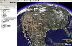
Today, weather info was added to the latest version of Google Earth. You can now see updated info on cloud cover, Doppler radar, temperatures, and weather forecasts for major cities worldwide. Data is updated frequently--from 15 minutes to an hour on average--for most parts of the globe. Sources of data include Weather.com and the Naval Research Labs' Marine Meteorology Division.
While you're checking out a travel destination, you can get other information about it, such as info on local hotels, photos of local attractions. Check the layer folder in the Layers panel, and click on the Places of Interest checkbox. Some options include Wikipedia info about destinations worldwide, Panoramio photos uploaded by amateur photographers worldwide, and YouTube videos uploaded by people worldwide.
If you like, you can download a file and see an animated version of clouds moving across the Earth's surface in the past day. (More info on that below...)
After you've updated to the latest version of Google Earth (info below), you'll find a fresh Layers panel in the bottom, left-hand corner of your screen. Under Primary Database, you'll find new boxes for Weather. Expand the Weather layer folder by clicking the + sign. Click whether you want to see Clouds, Radar, or the other options. Then search on a place where you want to see the weather, by typing its name into the search engine. For example, when you type "Colorado Springs, Co." into the search engine, you'll get a satellite view of the town. Adjust the viewer so that you can view the entire city. You can do this by zooming out or by expanding the size of the viewer itself (use the maximize window control or drag the size of the window using the mouse).
You can fly into and navigate very high resolution photos. To do this, in the Layers panel, check Featured Content > Gigapxl, and double click any photo icon in the 3D viewer. In popular destinations, You can easily view 3D models of buildings and more. To do this, check the 3D Buildings layer and tilt to get a better view
You can use placemarks to mark any location on the planet. You can then quickly go to the marked location at any time by double clicking the placemark in the Places panel. That way you don't have to redo your search to find a place, when you're doing trip-planning research.
Here's how to see animated images of clouds moving across the surface of the Earth, via the Google LatLong blog:
Download a time animation of the last 24 hours of clouds data by clicking here. Once you download the file, you'll see a new item in your "Temporary Places" folder in the "Places" panel (either "Clouds Animation"). Make the animation visible by checking its associated checkbox, then click the "Play" button in the animation control at the top right of your screen and wait for the data to load (even though the resolution isn't as high as the static image, it might take a little while). If you load the clouds animation (be sure to turn off the current clouds image), you'll be rewarded with a beautiful animation of clouds dancing and swirling across the Earth's surface.
If you already have Google Earth, you may need to upgrade to the latest version. You can download the latest version of Google Earth here. Click yes, save the file to your hard drive, then launch the file (which on a Windows computer will be "C:\My Downloads\Google_Earth_BZXD.exe"). The process takes up to 10 minutes on a broadband Internet connection.