Finally, a Tent With No Assembly Required

By Brad Tuttle
June 14, 2006

Update: On October 17, the U.S. Consumer Product Safety Commission (CPSC) recalled all Quechua tents and canopies--like the 2-Seconds Tent we covered in our July/August issue--because some may fail to meet the industry's flame-resistance standard, posing a fire hazard.


  • With the Quechua 2-Seconds Tent on your back, you look a bit like a Teenage Mutant Ninja Turtle
  •  

  • To open the tent up, just slide off one strap and fling it in the air. It's remarkably easy--and addictive
  •  

  • The tent is light and waterproof, and takes less than 30 seconds to fold up (decathlontent.com, $69)
  • Plan Your Next Getaway
    Keep reading

    Beat the Crowds in September

    After Labor Day, there's an absence of bugs as well as crowds at most parks, and the chill of winter hasn't set in yet. "September is an ideal month to visit the parks," says Rick Nolan, Chief of Interpretation at Redwood National Park in northern California. "Once the kids are back in school there's plenty of elbow room." Temperatures are in the 60s in early fall, and the average rainfall for September is less than two inches (compared to nearly a foot per month in the winter). Last year the park welcomed 64,000 visitors in July, but only 42,000 in September, making it the perfect time to soak in the primordial vibe created by the Pacific mist and the 350-foot-tall redwoods. At Crater Lake in Oregon, the last of the season's boat tours runs sometime in mid-September (541/594-3100, $26-$36). To board, you must hike down steep switchbacks for a mile. It's worth the trip: Nothing compares to gazing into the deep, electric-blue water up close. Head to the park's southeast corner to check out the jagged rocks known as the Pinnacles. "They're a cool geological formation that occurred when ash flowed during the eruption," says interpreter David Grimes. "The mountain had frothy flows of rock coming down the sides into valleys. Gas then superheated this ash to solidify it." The earth surrounding the Pinnacles eroded centuries ago, leaving behind spiny, gray rocks jutting up from the ground. The year's best weather at Acadia in Maine and North Cascades in Washington comes in July, August, and September, and the latter is by far the least crowded. "In September at Acadia it gets into the 60s during the day, which is great hiking weather," says park ranger Wanda Moran. "Even with the foliage season, it's pretty quiet compared to summer." The first leaves to turn colors are in the upper elevations, so hike to Beech Mountain (overlooking two ponds), or take the lazy route and drive up to the park's highest peak, 1,530-foot Cadillac Mountain. Sometimes at North Cascades it's not until late summer that all of the alpine trails are clear of snow. Hiking is the major draw, though you don't have to work hard for great scenery. "The views from the Cascade Pass Trail parking lot are just incredible," says Michael Liang, a park ranger. "You see glaciers and sheer cliffs as soon as you step out of the car." The vistas gets even better on the trail, which brings opportunities to run into mountain goats and furry little creatures such as marmots (oversized squirrels) and pikas (undersized rabbits). After ascending 1,800 feet in 3.7 miles, you reach a dramatic lookout for both the east and west faces of the Cascades. __________________________________________________ Plan Ahead Instead of paying for notoriously overpriced groceries, film, and outdoor gear inside parks or at tiny gateway towns that make a killing on tourists, stock up on supplies ahead of time in a large shopping center. __________________________________________________ Penguins and Jokers Not Welcome Thousands of Mexican free-tailed bats go through a nightly ritual at New Mexico's Carlsbad Caverns. Just after dusk, swarms come flapping out of the Natural Cave entrance to gorge on moths and insects. Flights occur from spring to early fall, and are most impressive in August and September, when newborns are old enough to join in the hunt. Visitors watch the spectacle from a stone amphitheater after listening to a park ranger give a free talk (575/785-2232; exact times change). By October the insect population is down and the bats have headed to Mexico for the winter.

    Beat the Crowds in July/August

    There's no getting around the fact that summer is peak season at most parks—but "peak" is relative. At Lassen Volcanic, an overlooked park in the northeast corner of California, you can hike all day on one of the busier trails in July or August and maybe see a total of 10 people. Lassen marks the south end of the Cascades, a mountain range that extends through the Pacific Northwest into British Columbia. The 106,000-acre park is unique for its hydrothermal features: fumeroles (like geysers), mudpots, and boiling springs. There are also dozens of lakes, hundreds of plant species, wide-open meadows, and a more than 10,000-foot dormant volcano. Because the park isn't on the way to or from any major attraction, Fourth of July and Labor Day weekends are typically the only times you have to worry about crowds. People who make it there love driving the beautiful, 30-mile Lassen Park Road (Hwy. 89) past lakes, forests, and remnant lava flow. Another favorite is the 1.5-mile walk to an elevated boardwalk leading through a basin of mudpots and steaming pools at Bumpass Hell, the park's largest hydrothermal site. The Cinder Cone Trail, in the remote northeast corner, is especially nice if you're out early in the morning, before it gets too warm. You trudge through sand-like soil for a few miles to magnificent views of Butte Lake, Lassen Peak, and the Painted Dunes colored in trippy browns, reds, and whites. Colorado also has a park that's under most tourists' radar, not only because it's miles from the nearest interstate but also because it became a national park relatively recently. After decades as a national monument, Great Sand Dunes earned the new designation in 2004. If you're not excited by a big pile of sand, you've never seen the dunes—nearly 30 square miles of them, 750 feet high, braced up against the 13,000-foot peaks of the Sangre de Cristo. Locals know to come to the park in early summer to play in the water streaming over the base of the dunes. Creeks often don't dry up until mid-July, around the time that the bright gold threadleaf goldeneye and other flowers are sprouting. "Basically anywhere there's water, you'll find wildflowers," says Carol Sperling, the park's chief of interpretation and visitor services. "Just go for a short walk along the creek on the Mosca Pass Trail or hike to some of the subalpine lakes in the high country." Temperatures in July and August hit the mid-80s in southern Colorado most days, dipping down to the 40s overnight, and there's little or no humidity. The sand can heat up to well over 100 degrees in the sun, however, so wear pants and boots if attempting to climb to the top of the dunes (at a good pace it takes about an hour). Miles and miles of more dunes come into view after cresting every ridge, and at the summit you can see across the valley to the San Juan Mountains 60 miles west. The sunsets are superb, casting yellows, oranges, and purples across the wide-open sky. Before nightfall there's generally a chance to witness why the peaks to the east were named the Sangre de Cristo. As the story goes, centuries ago a Spanish priest, dying from a wound in battle, cried out the phrase ("the blood of Christ") while looking up at the mountains as they turned a deep shade of red. _______________________________________________ 
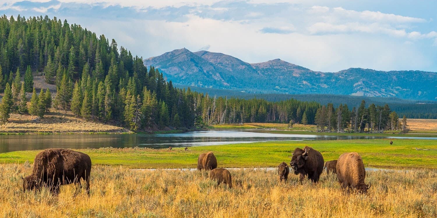
The Presidential Park It's hard to get further off the beaten path than North Dakota's Theodore Roosevelt National Park. The only time there's a real crowd is in August, when the Champions Ride rodeo saddles up nearby. Follow in Teddy's footsteps by hiking the Petrified Forest trail—with siliconized cypress trees everywhere, it's like walking in a forest of stone. Plus, you can spot bison herds.

    Beat the Crowds in June

    There's no predicting the exact day that Glacier's famous Going-to-the-Sun Road will open. Much of the 50-mile road, which zigzags up and over the tree line through the heart of the park in northwestern Montana, remains inaccessible to cars at least until mid-May. It takes most of spring to clear the snow that blankets the high passes. Chances are that the road will be totally open for the summer by late June. Park crowds, however, don't arrive in full force until Fourth of July weekend. Peak lodging rates don't surface until mid- or late-June either—both inside and outside the park you typically pay 10 to 20 percent less compared to July. The weather at Glacier can turn nasty without much notice. Even after the Going-to-the-Sun Road opens in its entirety, rangers are sometimes forced to close it for a day or two because of avalanches, rock slides, or fresh snowfall (possible year-round). There's a bonus when it's off-limits to cars: Bikers and walkers are still welcome on the road, and they don't have to deal with cars zooming by or exhaust fumes. Early summer is when Glacier most vibrantly comes to life. After a dark, cold winter and a thaw that seems to never end, the park's forests and meadows are at their greenest, yet the peaks are still gloriously capped in white. Bear, bighorn sheep, and other critters are out in abundance after months of inactivity. "Your chances of seeing wildlife are better in June than July or August," says park ranger Pat Suddath. "Moose are pretty elusive, but in early summer there are plenty of sightings, even of adorable newborns, in the Upper McDonald Creek Valley or the Many Glacier area." Harlequin ducks, covered in blue-gray feathers with brilliant patches of white, nest at Glacier for a few weeks and are gone by the end of the month. With all the melting snow and ice, June is the best time of year for photographing waterfalls or charging down the rapids on a white-water rafting adventure. And the days are never longer: The sun rises around 5 a.m. and sets at 10 p.m. To escape any semblance of a crowd, drive up the North Fork Valley on the park's west side. After 25 or so miles on a washboard dirt road, you'll reach Polebridge, a small outpost that's about as far out into the middle of nowhere as you can get by car. There's not much here except the Polebridge Mercantile (406/888-5105), a bright-red general store straight out of a Wild West movie that sells groceries, coffee, fishing tackle, and great baked goods; and the Northern Lights Saloon, a funky cafe with picnic tables, huge burgers, and cold microbrews on tap. ___________________________________________ Hiking Without Borders Glacier is just part of the larger Glacier-Waterton International Peace Park, with protected land on both sides of the Canadian border. On Wednesdays and Saturdays from mid-June to early September, one American and one Canadian park expert jointly lead a free International Peace Park Hike. Walks start at 10 a.m. at the Waterton townsite, heading south along the west side of Upper Waterton Lake. Hikers head to the Goat Haunt Ranger Station in Glacier. From there, most folks hop the $15 ferry that arrives back where the hike started in Waterton around 6 p.m. (406/732-7750, reservations required). ___________________________________________ Leave the Car Behind Amtrak trains stop at three depots in northwest Montana—East Glacier Park, Essex, and West Glacier—where you can get off and literally hike right into the park. Add in a system of hiker shuttles (which sometimes don't start until July; call for details) that pick you up and drop you off right at the trailhead, and Glacier is one of the few parks where you don't need a car.

    Beat the Crowds in May

    The national parks of southern Utah maintain a friendly rivalry. Each has its bragging points: Bryce Canyon is loaded with photogenic spires known as hoodoos; Zion offers imposing cliffs and lush hanging gardens; Capitol Reef has brilliant, colorful canyons and odd rock formations; Canyonlands wins in terms of overall size; and it's pretty obvious what Arches is known for. Much of Bryce Canyon is more than 8,000 feet high, and in early spring you'll probably have to deal with snow and mud. Tourists flock to southern Utah in summer, so May is a good bet for smaller crowds, drier terrain, and more predictable weather. One of the prettiest and most popular trails at Bryce combines parts of the Navajo Loop and Queens Garden trails (2.9 miles total) for great photo ops of delicately eroded hoodoos. You're more likely to spot mule deer, elk, and dozens of bird species in the forest on the 8.5-mile Riggs Spring Loop. At one point the trail opens to spectacular views of the Pink Cliffs on the southern edge of the park. Hiking doesn't have to stop when darkness falls; the sky is clear enough for full-moon walks, sans flashlight. The terrain over at Zion is varied, with soaring cliffs, narrow canyons, and emerald pools. While it's warm in May (often in the high 80s), you won't encounter the three-digit temps of midsummer. To cool off, scamper up to Weeping Rock—the quarter-mile trail is shady, but steep in spots. In a grotto area, water continuously "weeps" down tall sandstone walls that are overgrown with hanging gardens. Real adventurers can take on the Zion Narrows, hiking in and along the Virgin River in a 1,000-foot crevasse. The water should be gushing and extra chilly in May; ask a ranger about flash flood dangers and water conditions beforehand. _______________________________________ Proof You Were There More than 400 parks, monuments, and historic sites fall under the domain of the National Park Service. The pocket-size Passport to Your National Parks ($8) serves as a checklist for all those great sights, from Appomattox Court House to Zion National Park. The 104-page book, available at most park gift shops and at eparks.com, comes with thumbnail descriptions of what to see divided by region, plus a U.S. map highlighting federally protected spots. Blank pages are set aside after each region for collecting national-park stamps (a new set is issued every year) and ink seals of sites you visit. Get your passport stamped at the visitors center before leaving.