6 Cool Pedestrian Bridges You Should Walk Across
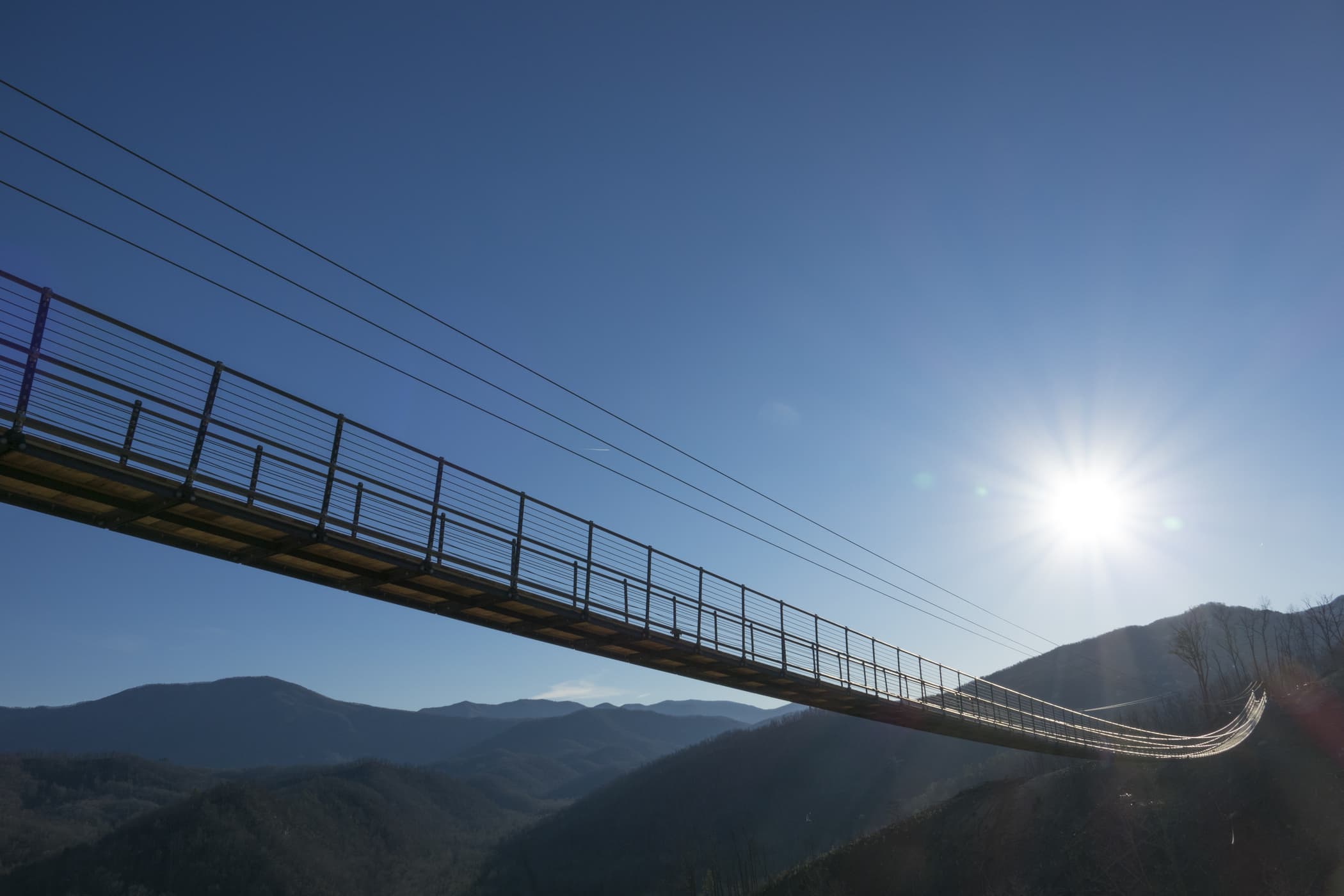
Gatlinburg’s SkyBridge, which opened today, is the longest pedestrian suspension bridge in the U.S., spanning 680 feet over a valley in the Great Smoky Mountains. An impressive feat indeed, but it's not the first of its ilk—from coast to coast, the United States is full of show-stopping structures just waiting to be explored. Offering epic views of manmade skylines and natural wonders alike, here are six awesome American bridges perfect for a stroll.
1. Skylift Bridge: Gatlinburg, Tennessee
 (Courtesy SkyLift Park)
At the top of Crockett Mountain, on the edge of Great Smoky Mountains National Park, SkyLift Park (gatlinburgskylift.com) is home to that brand-new record-breaking suspension bridge. At its highest point, it's 140 feet off the ground, but you don’t have to make the climb on your own. Take the chairlift, an iconic Gatlinburg attraction dating to 1954, and get off at the top, where you can hang out on the deck to nurse a pint, snap the perfect selfie, and oh yes, conquer the bridge. The walking path is five feet wide, so you shouldn’t have to worry about navigating the right-of-way in tight environs (when in doubt, single file!), but don’t look down if you’re squeamish—especially in the middle, where glass panels let you see past your toes and straight into the depths below.
Tickets, $20 for adults, $18 for seniors, $15 for kids ages 4-11, ages 3 and under free. The lift is accessible for passengers who are able to stand up to load on and off, and wheelchairs can be rented for free at the top, but the bridge itself is not wheelchair accessible.
2. Navajo Bridge: Glen Canyon, Arizona and Utah
 (Amelia Takacs/Dreamstime)
The first direct route between Utah and Arizona, the Navajo Bridge (nps.gov/glca) opened to cars in 1929, and for nearly 70 years, drivers on highway 89A took that route to cross the Colorado River. But the area’s transportation needs eventually overwhelmed the historic structure, and its 18-foot-wide road became too much for the heavier cars and trucks of the late 20th century. Construction began on a new bridge that would run parallel to the old one, and upon its completion in 1995, the original bridge was opened to foot traffic. Today, the steel-and-concrete trestle looms 467 feet above the river, with a visitors center and a bookstore on the west side. On the Navajo Nation side to the east, Native American craftspeople set up shop, and the Navajo Bridge Interpretive Center offers outdoor exhibits and self-guided walks across the bridge.
Park entry, $30 per car or $15 per person on foot or bike. The historic bridge is wheelchair accessible.
3. BP Pedestrian Bridge: Chicago
 (F11photo/Dreamstime)
The BP Pedestrian Bridge (millenniumparkfoundation.org), Frank Gehry’s first and, to date, only bridge, can be found in downtown Chicago, where it wends its way over Columbus Drive, connecting Millennium Park and Maggie Daley Park over lane upon lane of urban traffic. Completed in 2004, the undulating overpass is covered with the famed architect’s signature sculptural stainless-steel panels and spans nearly two-tenths of a mile, providing both skyline and park views along the way. It’s also a companion piece to Gehry’s Jay Pritzker Pavilion—though the outdoor amphitheater has an impressive aerial sound system, the bridge contributes to the experience, serving as an acoustic barrier for free performances and festivals of all stripes.
Free. The bridge is accessible, with gently sloping wheelchair-friendly ramps at each entrance.
4. Tilikum Crossing: Portland, Oregon
 (Vitpho/Dreamstime)
With a Native American name symbolic of connection and friendship that nods to the region’s early people, Portland’s Tilikum Crossing (trimet.org/tilikum) opened in 2015, becoming the area's first new bridge across the Willamette River in 40-plus years. Roughly 1,700 feet long and utilizing more than three miles of cable, the cable-stayed bridge has lanes for buses and trains and separate paths for cyclists and pedestrians—no cars allowed—with a design takes its cues from the surrounding landscape. The sloping angle of the top cable mimics the slope of Mt. Hood in the distance, while the 180-foot-tall towers at the bridge's center have angled tops that blend with the tree line. Taking it to the next level, aesthetic lighting works in direct synthesis with the environment: LED lights on the cables and towers change color based on the flow of the river, with the water’s temperature affecting the shifting hues and its speed setting the pace for the colors' movement across the bridge.
Free. The bridge is wheelchair-accessible, with extra-wide pullouts around the towers where visitors can pause to take in the views.
5. Bob Kerrey Pedestrian Bridge: Omaha, Nebraska, and Council Bluffs, Iowa
 (Courtesy VisitOmaha.com)
At 3,000 feet, including its landings, the Bob Kerrey Pedestrian Bridge (visitomaha.com/bob) is the longest footbridge connecting two states, stretching over the Missouri River between Omaha, Nebraska, and Council Bluffs, Iowa. Since its official opening in 2008, the walkway has become so integral to the communities it links that it’s taken on a life of its own: Named for the former Nebraska governor and state senator who championed the project, it’s now known simply as Bob, an anthropomorphic structure with an active social-media presence and a few thousand followers. The cable-stayed bridge features 210-foot LED-lit pylons and a curving pathway that echoes the winding river beneath, hovering 60 feet above the Missouri at its midway point and connecting to 150 miles of nature trails and family-friendly public spaces on either side.
Free. The bridge is wheelchair accessible and ADA-compliant.
6. Walkway Over the Hudson: Poughkeepsie, New York
 (Liz Van Steenburgh/Dreamstime)
Opened in 1889 as the Poughkeepsie-Highland Railroad Bridge and transformed into a pedestrian trail in 2009, New York’s Walkway Over the Hudson (walkway.org) is a state park with a storied history. Originally introduced as an industrial line, the bridge was transporting passengers between major east coast cities within a year of its debut; during World War II, it was painted black to prevent against attacks, and in 1974 its tracks were destroyed by a fire likely sparked by a train’s brakes. Today, some half a million people travel the 1.28-mile footpath from Poughkeepsie to the town of Lloyd in Ulster County, soaking up gorgeous, 360-degree views of the Catskills and the Hudson Highlands from 212 feet above the river. For even more natural splendor, the linear park connects with two rail-trail networks, the Hudson Valley and the Dutchess, to offer 18 miles of walking and cycling in verdant environs.
Free, except during special events. Both entrances are wheelchair accessible and ADA-compliant, and a 21-story glass elevator operates seasonally on the Poughkeepsie side.
For travel inspiration, know-how, deals, and more, sign up for Budget Travel's free e-newsletter.